
The Willow Heights Trail is located in Big Cottonwood Canyon. Driving up the canyon, we found it on the left side of the road shortly after passing both the Silver Fork Lodge on the right and the Canyon Vacation Rentals on the left. Hiking and camping were the only recreation allowed. Free parking was limited in availability along both sides of the road. There were not any facilities for restrooms and water. My cell phone service was stronger higher on the trail than it was on the road.
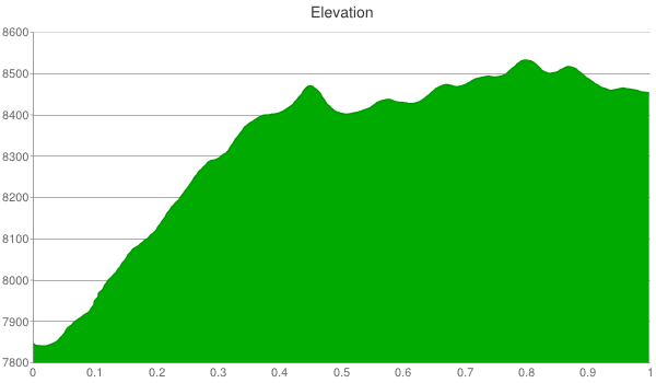
We hiked 0.75 miles up to the edge of Willow Lake, 0.65 miles around it, and then 0.75 miles back down to our car for a total of 2.15 miles. The chart below represents our 600 foot elevation gain up to and around the lake (not including our way down).
We had a hard time finding the trail head because nobody was parked there when we arrived. It can be easily identified when heading down the canyon by looking for a 35 mph sign. By the time we had left, several cars were parked on both sides of the road.

The trail was narrow throughout with a mix of smooth and rocky terrain.
 It was steep with a consistent grade. The seven year old in our group had no problem with the elevation gain but the four year old needed some encouragement.

Many wildflowers were in full bloom. I believe the following was a sunflower.

In addition, we saw several moths.

There were several of these geraniums.

And, lots of Indian paintbrush.

The Aspen trees offered shade and a serene backdrop that was enhanced when the wind blew through their leaves. We wore shorts but wished we had worn pants because vegetation was growing across the trail in several spots.

After about a half mile, the trail leveled off and led us to a meadow. Willow Lake was beyond the meadow’s small hill seen in the next picture.

The trail looped around the lake. We took a left turn (i.e., headed west) and reached the water’s edge after a short distance. The east side of the loop did not offer a view of the lake. This was the view from the southwest corner.

We continued clockwise around the lake.

I didn’t get good pictures of them but we saw Uinta Ground Squirrels and several diving water birds. The video below captured the placid ambiance.
The next photo was taken from the north end of the lake.

We continued clockwise around the loop. After the lake was out of our view, the trail felt like it had been rarely traversed with vegetation layered across it and at a height of over four feet. In addition, at 0.65 miles the loop was longer than we expected. We had fun fighting through the vegetation but in the future we probably won’t walk all the way around the lake.

In sum, we enjoyed a late afternoon hike up to Willow Lake. The climb was tough but the lake was worth it and the descent felt easy. Doughnut Falls and trails around Silver Lake are two similar Big Cottonwood Canyon areas.
