Squaw Creek Park is in Marion, Iowa near the intersection of US-151 and Collins Road. The multi-use grass paths were open to biking, dog walking, horseback riding, cross-country skiing, and running. There was a two mile single track mountain biking loop that was off limits for horses and that has been scheduled to be closed every year from October 1st through January 31st to allow permit-only bow hunting. On the park roads, I followed signs for “mountain biking” and parked in a large free lot. It did not include water or restrooms but other areas of the park did. My cell phone service was strong.
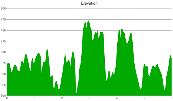
Starting from the mountain bike trail sign, I rode on all of the multi-use grass paths for a total of 6.5 miles and within an elevation range of 150 feet.
Not knowing where the single track trail was, I turned left at the bottom of the hill (seen in the picture below).

There were wood posts with maps scattered throughout the park but they didn’t include the single track trail. After turning left at the bottom of the hill, I turned right and biked on the out and back grass path that ends with a short loop. I saw a buck in the woods off of this path. In addition, I saw several wild turkey scattered throughout the park.

After returning to the bottom of the aforementioned hill, I took the path to the right. The single track trail’s east entrance was located after only a short distance and identified by a “horses prohibited” sign. At this point, I decided to complete the large multi-use loop in the clockwise direction.

The southeast corner of the multi-use loop had a narrow hiking trail that was sandy and overgrown with vegetation, so I didn’t fully explore it.

I continued clockwise on the main path. The grassy trails on the east side were flat but on the west side they were hilly.

After I passed a park bench and a map post on my right, I reached a fork in the path. I chose the left side (headed west), got lost, and ended up at the gate in the next picture.

I turned around and took the right side of the fork; which led me north and kept me on a large clockwise loop.

At a little more than half way around the loop, I reached the Meadowlark Shelter. It had restrooms and a large picnic area.

I biked around the western end of the shelter’s parking lot and into the dog exercise area. It was scenic with a small pond and an open landscape.

From there, I crossed Ski Lodge Road and continued until I had completed the multi-use loop.

I mountain biked on the single track trail that was recently created by the Linn Area Mountain Bike Association. It was a two mile loop atop hilly terrain and within an elevation range of a 100 feet.

The single track loop was fully encapsulated inside the southern end of the larger multi-use loop. It had two entrances. The first was on the east side near the designated parking area and which I found by taking a right at the bottom of the hill seen in the first picture of this post. The second was located off of the western side of the multi-use loop and which I estimated was the lesser used of the two. I biked a clockwise loop by turning left at a fork only a hundred feet onto the trail. Unlike Sugar Bottom, the trails were bidirectional so either way would have been fine.

It was narrow, smooth, hilly, and curvy. I don’t remember any fast straightaways. I stayed left at the second fork (not pictured) and later figured out that the right turn was for a short connector trail that led back to the east entrance.

It featured several log ramps that were fun and relatively easy to manage.

The southeastern corner of the loop was delineated by a clearing in the woods that allowed power lines to pass through the park.

From end to end, the trail was action-packed with a nonstop array of twists, turns, short climbs/descents, and log ramps. In addition, there were numerous fallen trees, most of which I hopped over without any problem. However, I walked my bike over a few of the larger, intimidating ones (e.g., like the one in the next picture that rested at a tough angle).

The fallen trees featured in the next picture should not have caused me any issues but they did. My approach was too slow and I leaned forward to (probably unnecessarily) duck below the overhanging tree. When I hit the fallen trees, I started a slow-motion fall over my handlebars with the bottom of my front tire as the pivot point. I fell to the right and at a slow enough speed that I landed unscathed. Overall, the trails felt moderately challenging but my fall reminded me that it can be easy to underestimate the difficulty of a single section.

The fallen tree in the subsequent picture was an example of a small to medium sized one that was easy and fun to hop over.

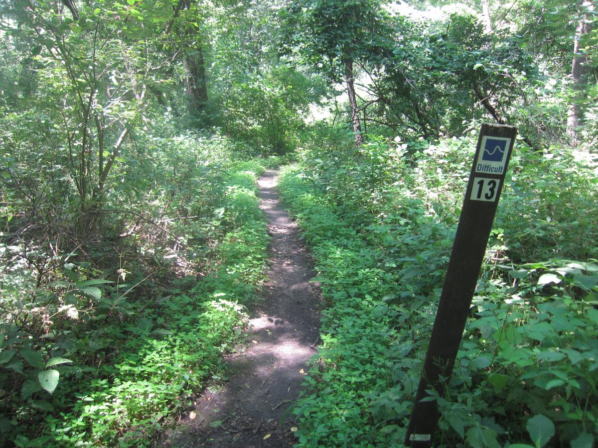
The third forked intersection had a sign labeled #14. I turned left and it led me a short distance to the west entrance off of the multi-use path. I returned to the fork, took the right turn, and continued on the clockwise loop. My loop ended near a sign labeled #13. It wasn’t clear to me where #13 and #14 started and ended.

In sum, the multi-use paths were easy but interesting. The single track was fun and action-packed with a few intimidating fallen trees scattered throughout. For more mountain biking, check out the larger Beverly Park and the smaller Thomas Park. Lastly, this park had two lodges and a large campground (seen below).

