The Cat and Thomas Mountains Preserve is located in Bolton Landing, New York and about 20 minutes north of Lake George Village. We drove north on 9N, turned left on Bolton Landing-Riverbank Rd, turned left on Valley Woods Rd, and shortly thereafter found the trail on the right side of the road. Hiking, dog walking, and cabin camping are the featured outdoor recreation in the preserve. Parking was free but limited to about 6 cars. Restrooms and water were not available. I had intermittent cell phone service.
We hiked a 3.3 mile counterclockwise loop up to the cabin on Thomas Mountain, which had a range in elevation of 800 feet.
We started on the Orange Trail, which is an old logging road that was wide and smooth.

After we passed an old gravel pit, we turned right onto the Two Brothers Trail, which was clearly identified by blue markers and signs. We chose it because we were only interested in hiking up to and around Thomas mountain, and it offered the most interesting route. For the purpose of hiking to Cat mountain, I recommend taking the Orange trail to either the Yellow or the Richard Hayes Phillips Trails because they provide a more direct route to that summit.

The first part of the Two Brothers Trail followed and crossed a stream that was gushing from the recent heavy rains.

I spotted a camouflaged wood frog only because it jumped out of the way of my foot. Can you see it in the next picture?

The trail was mostly smooth but did have a few areas of rocks and narrow passages. In addition, its steep slope was offset by timely switchbacks.

We gave the right of way to a very small red-spotted newt.

Near the summit, we followed blue signs for the scenic outlook offshoot trail.

On our way to the scenic outlook, we came across what look liked a possible trail, but the yellow marker had faded writing and seemed intended to discourage people from hiking there; thus, we didn’t explore it.

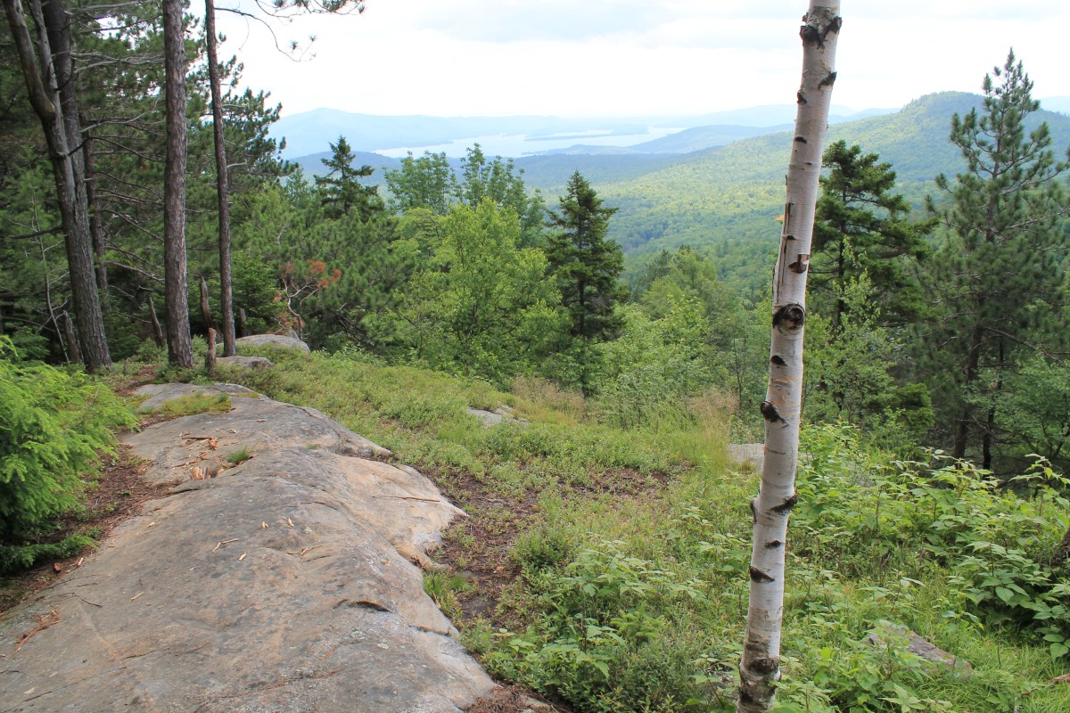
The view from the overlook was expansive, even on a hot and hazy day, as it was when we were there.

This first video captures sights and sounds from the overlook.
From the overlook, we back-tracked to the Two Brothers Trail and continued our counterclockwise loop. This trail was more fun because it elegantly meandered through the forest and up the mountain whereas the Orange trail was almost straight up and down and without switchbacks.

The view from the cabin includes Lake George and looks west and south.

The cabin was first-come, first-serve and offered shelter for overnight visitors. Behind it was an outhouse equipped with toilet paper, but camp fires were not allowed.

This second video was taken from the cabin and peers inside it.
Behind the cabin about a hundred feet, we saw an orange marker which lead us down the Orange trail. It was the fastest way back to the parking lot because it was direct, primarily smooth, and wide.

Before we reached the parking area, we walked through a swarm of jumping grasshoppers.

In sum, we thoroughly enjoyed hiking a loop up to both the scenic overlook and the cabin on Thomas Mountain. The Two Brothers Trail was tranquil, interesting, and challenging. Buck Mountain and Pilot Knob Mountain are nearby hikes of similar length and difficulty.
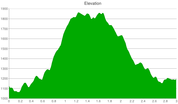
In July 2010, my mom hiked the logging road (Orange trail) to Thomas Mountain and then completed the full loop to Cat Mountain using both the Richard Hayes Phillips and Yellow trails. The total distance for her was 7.4 miles with a range in elevation of 800 feet. The elevation chart illustrates that from Thomas the trail dips before rising up to Cat and, thus, there was a significant total elevation change, which her phone estimated was 3000 feet.

