
Ensign Peak Nature Park is located 15 minutes north of downtown Salt Lake City and less than two miles north of the State Capitol Building. Hiking and dog walking were the primary outdoor recreation since bikes were not allowed. A limited amount of free parking was available along Ensign Vista Drive. Restrooms and water were not available. My cell phone service was strong.
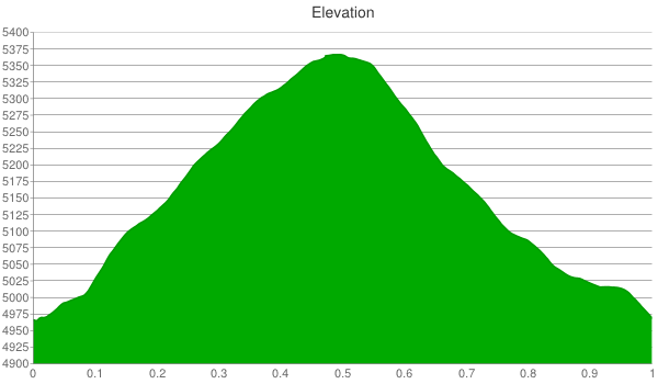
I hiked 1.0 miles total (out and back) including the vista mound near the trailhead. It was almost 400 feet of elevation gain to the peak.
The only shaded area was a 30 foot long section seen in the next picture.

The trail was wide, smooth, and a little dusty (i.e., slippery). On my way up, I passed a group of preschoolers and they seemed to be having fun on their way down. The short distance should make the steep terrain doable for hikers of all skill levels.

It continued through a dense shrubbery that I have yet to identify.

About two-thirds the way to the peak on the north side of the mountain was a viewing area that overlooked the Great Salt Lake.

Near the peak was a rock outcrop that was the only section that required any special attention.

The summit had a viewing plaza that featured the “Ensign”.

The view was panoramic and unobstructed to the west, south, and east. It featured downtown, the mountains to the east, and the Great Salt Lake to the west.

It was windy at the peak so I apologize for the sound of it in the video below.
On my descent and close to the trailhead, I hiked on the short trail to the vista mound.

This viewing area provided a closer look of downtown.

From here, I took another video.
In sum, this was a quick and easy hike with great views. I recommend three hikes that are east of downtown and of similar length and difficulty: Cecret Lake, Doughnut Falls, and Silver Lake.
