McAfee Knob is located northwest of both Roanoke, Virginia and I-81. From I-81, take exit 140 or 141, head north, and follow VA-311 N 5.6 miles to the trailhead; located at the top of a ridge. Outdoor recreation includes hiking, dog walking, and camping (at designated sites) but not horseback riding and mountain biking. The parking lot is huge but does not include restrooms and water. Cell phone service was medium to strong on the trail.
The hike to McAfee Knob is 3.5 miles along the Appalachian Trail. It starts at around 2,000 feet and peaks at the knob at around 3,200 feet. The estimated elevation chart illustrates how the trail is rolling for the first two-thirds of the hike and then begins to climb at the end. The trail has very few switchbacks because the slope is moderately inclined. Before the hike, I assumed the 1,200 foot elevation gain would be more challenging than it turned out to be.

To start, cross the street and follow white blaze Appalachian Trail trail markers. From the McAfee Knob parking lot you can also hike on the AT south to Dragon’s Tooth but it has its own parking lot that is a little closer to the summit.

The trail follows the top of a ridge and rolls up and down gradually. There are several wood walkways that mask rocky terrain.

On the way to McAfee Knob you pass two shelters. The first one is reached after one mile and is named John’s Spring Shelter. It includes a picnic table, a fire pit, and an outhouse.

Although this hike was easier than expected, I would not carry a child in a carrier for two reasons. First, the seven mile round trip would be challenging for me physically and is likely to be too much time for our daughter to be confined. Second, the trail includes some rocky stretches and numerous step-ups and step-downs where the added weight would be tough on my knees. On the other hand, carrying our daughter in a carrier to Cascades worked out great because she had fun at the waterfall and the four mile round trip was not too taxing on us.

In the summer, the forest canopy offers shade protection whereas in the fall there are more opportunities for views both to the north and south.

The second shelter is passed after two miles and is named Catawba Mountain Shelter. It includes a picnic table and a fire pit. If it has an outhouse then I missed it.

In addition, there is a spring water source nearby (seen below).

Just past this shelter is a designated camp site with its own fire pit.

After the campsite, it is 1.5 miles to McAfee Knob. Notably, it is over the last mile and a half that most of the elevation gain occurs. Although power lines are not ideal, they result in a scenic meadow in the picture below.

The next picture shows a tree with a double white blaze trail marker, which indicates an obscure turn, route change, or incoming side trail. There are several of these on this hike so be sure to keep a look out for them.

The subsequent picture contains a silhouette of what I believe to be a small woodpecker. I was unable to identify it because of my novice birding skills but it was fun to see.

The final stretch of trail is on the north side of the ridge and continues until you reach blue blaze trail markers that lead to the knob.

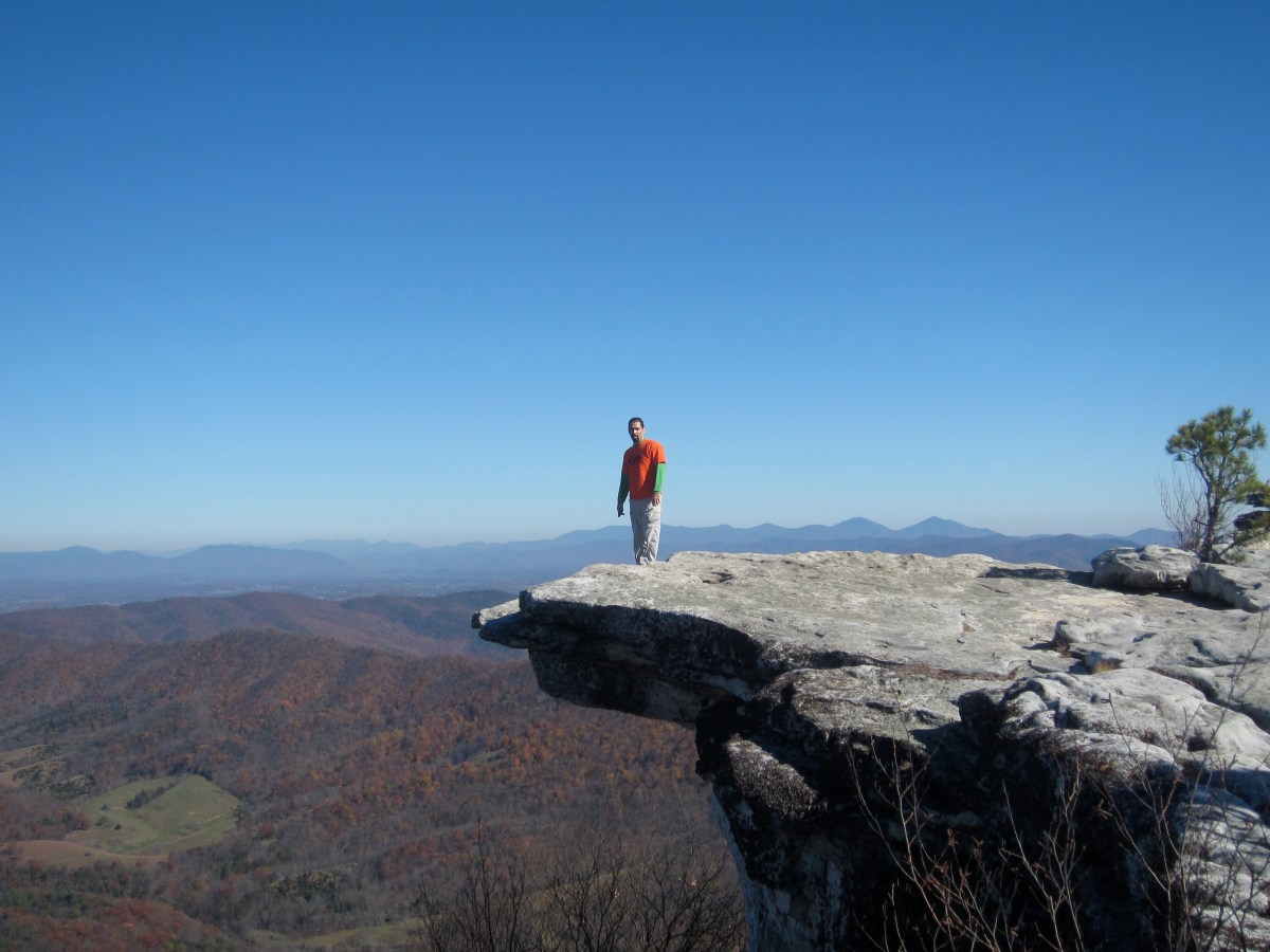
The following picture includes the iconic McAfee Knob, rumored to be the most photographed spot on the Appalachian Trail.

The subsequent picture peers north from the knob.

Continue to walk east along the rocks and go around a bend to see a clear view of downtown Roanoke and the Roanoke airport.

The following panoramic picture shows that the vista from McAffe Knob is at least 180 degrees.

The following video demonstrates that there is plenty of space to have a picnic on or near the knob. We visited on a quiet Thursday the second week of November, but it is easy to imagine the knob being crowded with people on the weekend.
I completed this hike the second week of November but first visited the trail the second week of August. On my August trip, it was hot and hazy and one of our group members got sick so we didn’t make it to the knob. However, on that day I met Cyron. He was in the process of hiking the Appalachian Trail from Massachusetts to Georgia and hoping that his pet iguana would be the first iguana to complete most of the AT. He said that McAfee Knob was the most scenic lookout he had come across on the AT up to that point. His iguana appeared very comfortable perched on his backpack (seen in the following picture).

In sum, the hike to McAfee Knob is long, not very strenuous on a cool day, and very rewarding, especially on a clear fall day when autumn colors are in full effect. I usually only hike a trail once but this experience was awesome and warrants repeat visits. Other nearby day hikes on the Appalachian Trail include Angels Rest, Dragon’s Tooth, and Kelly Knob Overlook.

Thank You for your very descriptive detail of the trail. Also the pictures you included were very helpful. I been wanting to do it but some people say it is tough. I think I will give it a go.
Laura Zabinski
You’re welcome and have fun! I recommend hiking it before it gets too hot.
Great job of writing up this trip. I checked my AT Journals and I last hiked this in September of 2000. I want to take my wife on a shorter version of this so perhaps an overnighter at one of the shelters you mentioned would be nice. Again, great job on this write up.