
The Lofty Lake Loop starts from the Pass Lake trailhead at mile marker 32.1 on the Mirror Lake Scenic Byway (UT-150) and is also about 32 miles from downtown Kamas, Utah. Outdoor recreation from this trailhead includes hiking, hiking with dogs, backcountry camping, and horseback riding but mountain bikes are prohibited. A fee is required to park inside Mirror Lake Recreation area. The Pass Lake trailhead include restrooms and a medium sized parking lot but no water. Cell phone service was very weak at best but my phone recorded accurate GPS coordinates.

From the Pass Lake trailhead, there are three lakes that can reached on a day hike: Kamas Lake is 2 miles hiking clockwise; Lofty Lake is 1.5 miles hiking counter-clockwise; and Scout Lake is 0.5 miles hiking counter-clockwise. The Lofty Lake Loop consists of all three lakes, is 3.8 miles long, and ranges in elevation from 9,780 to 10,840 feet. We intended to hike the Lofty Lake Loop clockwise but made a wrong turn after passing Lofty Lake and ended up hiking all the way to the Ruth Lake trailhead. I recommend hiking the loop counter-clockwise because it reduces the chance of making an error. The following chart shows the relative elevation change and, notably, illustrates how the trail dips at the beginning before transitioning to a steady climb until it reaches Lofty Lake.

This is a long hike so I recommend starting early in the morning to reduce the chance of getting caught in a storm; more on that later. The trail is rocky and narrow in some places which results in slower hiking but the rugged terrain didn’t seem to phase our dog. Stay to the right at the first couple of intersections.

Early in the hike, we walked through a beautiful meadow that features two peaks. Here, we were bit by bugs so I recommend bringing repellent.

After dropping down into the meadow, we climbed up and over a ridge to get to Kamas Lake. We found it to be a majestic and relaxing place to have lunch. We visited on the first Friday in August and saw only three other hiking groups so we felt like we were all alone in the wilderness. This magnificent lake, and the High Uintas in general, reminded me of Rocky Mountain National Park but it didn’t have the crowds and restrictions (that apply to dogs and horses) of a national park.

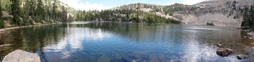
The following panoramic picture captures the fact the shoreline is mostly woody with a rocky edge on the far side.
The subsequent video was taken near the shoreline of Kamas Lake.
After Kamas Lake, the trail continues to slope up and then levels off through another meadow.

After meadow number two, the trail switchbacks up the side of a ridge and offers unobstructed views of a vista to the north.

Cutthroat Lake can be seen below with Wyoming in the distance.

Lofty Lake is next and also the high point of this hike. A storm was bearing down on us so we didn’t stop to enjoy it.

To complete the Lofty Lake Loop, we were supposed to hike to Scout Lake (a glimpse of it can be seen in the picture below).

However, after we completed the steep descent from Lofty Lake, our fear of the storm had us moving too quickly. The trail was a little less distinct and I saw a tree off to the left that was marked with a pink ribbon and subsequent cairns denoting a trail. We chose to follow the cairns (i.e., an incorrect left turn) that lead us all the way to Ruth Lake; which by the way is huge mistake. Check out the Google Map above to see how much shorter the hike would have been had we correctly followed the trail to Scout Lake. The following picture includes a segment of trail that we tracked using cairns and that connects Lofty Lake to Ruth lake.

Ruth Lake can be seen below and, although beautiful, we didn’t stay long because we were still being chased off the trail by a storm. We did see some people camping near the shoreline across from us. It was at this point that we realized our mistake because we knew Scout Lake had boating docks and Ruth Lake had none.

From Ruth Lake, it was 0.75 miles to the Ruth Lake trailhead. Notably, the Ruth Lake trail had interpretive signs and seemed like an ideal hike for kids.

The Ruth Lake trailhead is 3 miles away from the Pass Lake trailhead so we enjoyed a long walk back to our car. On our walk back, we stopped by Butterfly lake (seen below); which is wheel chair accessible from the road and was bustling with people fishing.

Despite our big error, we felt lucky that the storm had subsided and that we didn’t have our toddlers with us. Otherwise, our error would have been a big disaster.

Before heading home, we stopped by Mirror Lake to have a snack. It is a hub of activity including camping, speakers at an amphitheater, fishing, picnicking, and more.

In sum, I highly recommend the High Uintas and the Lofty Lake Loop because the area has a national park feel without national park crowds and restrictions on dogs and horses. Hiking the Lofty Lake Loop with our unintended extension to Ruth Lake would have been extremely fun had we brought two cars and parked one at each trailhead. This was my first visit to the High Uintas and I hope to visit again. Until I do, I recommend the following trails near Salt Lake City:

I haven't visited much of Utah, but when reading your reports I sure get the longing to.
Thank you for the comment. Utah is awesome with its diverse landscape. Looks like you had a great trip to Yellowstone National Park. I've never been there but hope to visit soon. Let me know if you start a Twitter account and I'll give you a Twitter shout out.