Mountain Lake is about 17 miles from Blacksburg, VA. Directions from Blacksburg: take 460W, turn right onto Mountain Lake Road (State Route 700), and drive on Mountain Lake Road for seven miles. Outdoor recreation includes hiking, mountain biking, and frisbee golf but pets, camping, and picnicking are not allowed. Parking requires either a day pass (purchased at parking lot) or an annual pass (purchased at the Visitor Center). There are two parking lots: a year round lot one mile north of the hotel and a part-year lot at the south end of the lake (in front of the Hotel and Visitor Center). The year round lot does not include restrooms or water but the barn across from the Visitor Center does. Cell phone service is weak to medium.

From the Hotel parking lot there are a couple of fun loops that start with the Golf Course Road trail. The first loop I biked was Gold Course Road to White Dot Trail. The second loop I biked, and the one I had more fun with, was Golf Course to Upper Doe Run, left onto White Dot, right onto Lower Doe Run, right onto White Pine Road, and, finally, a right onto Upper Jungle Trail.
Upon leaving the hotel parking lot, I found the starting point for Golf Course road by biking on Mountain Lake Road north, turning left onto Girls Camp Road, and following signs leading towards the Blueberry Ridge Cottages. However, after finishing my second loop I discovered that it is shorter to leave the hotel parking lot and take Golf Links Lane, which is the short road immediately across the street from the hotel. Golf Links Lane has cottages which can be seen before turning into the hotel parking lot. Golf Course Road is about a one mile long with an elevation gain of 200 feet.

It is a gravel road with a moderate climb.

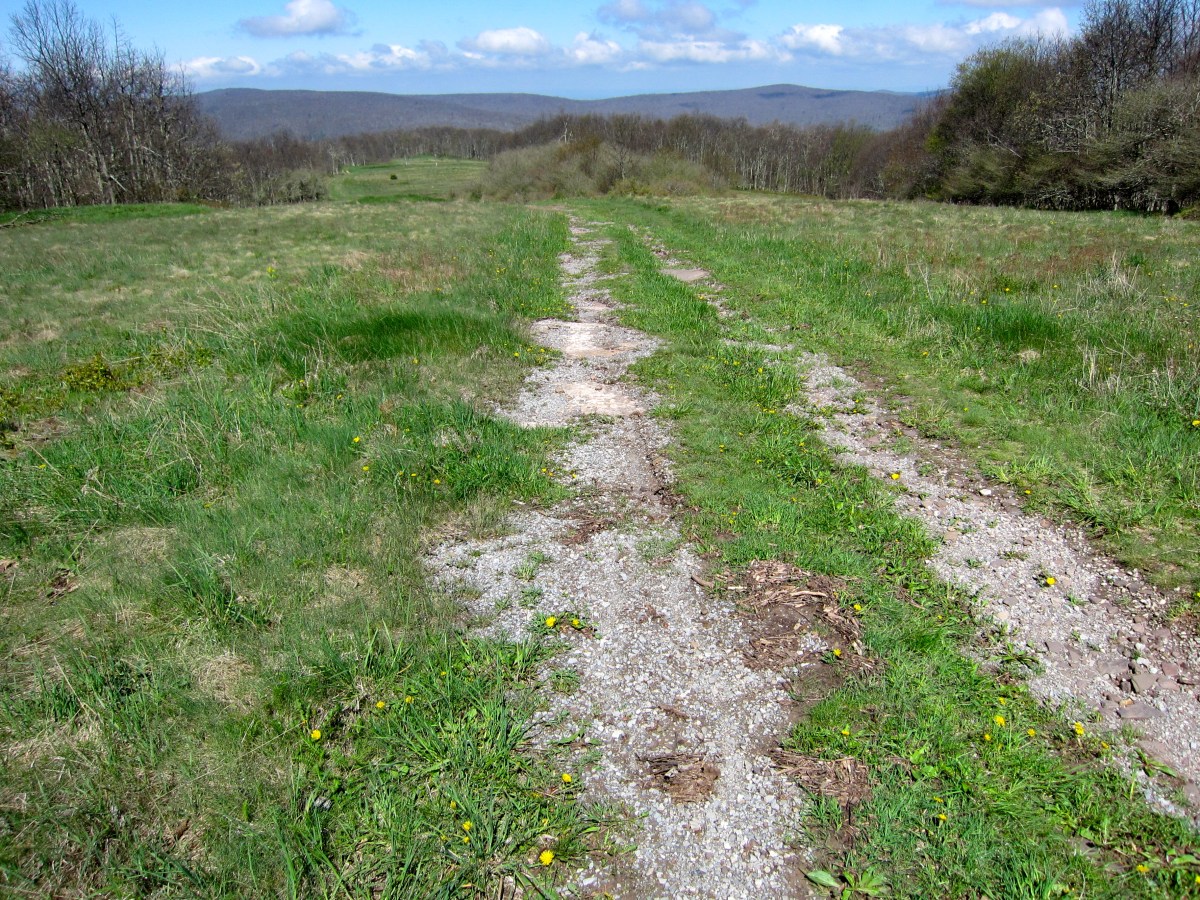
It is a scenic trail that includes an unobstructed view to the north. It ends in a grassy field and along the tree line with an intersection with the White Dot Trail.

The White Dot Trail is 1.6 miles long with a range in elevation of 300 feet.

From Golf Course Road, it starts with a moderately challenging descent. There are very few switchbacks on the trails at Mountain Lake. Therefore, the primary challenge with mountain biking on them is that it is either straight up or straight down a mountain. In addition, the trails have an untamed and wild feel to them because they are rarely smooth and almost always a little bumpy with a mix of grass, rocks, divots, and fallen trees.

After the descent, there is a moderately difficult climb on semi-rugged trail. It ends with a grassy surface and at an intersection with the Girls Camp Road.

After riding a Golf Course Road and White Dot loop, I biked on a longer loop that included Golf Course Road, Upper Doe Run, White Dot, Lower Doe Run, White Pine Road, and Upper Jungle. I biked on Golf Course Road for a half mile to reach the intersection with the Upper Doe Run trail. From there, it is a descent of 200 feet to an intersection with White Dot.

It is an easy trail with fallen trees being the only obstacle.

From the White Dot trail, I biked on Lower Doe Run to White Pine Road. Riding west to east, it is an easy 250 foot descent.

It difficult to bike the descents at Mountain Lake fast because there are numerous fallen trees and other obstacles hiding above and below the leaves. However, I imagine that the trees are cleared as it gets closer to the busy summer season.

Next, I biked on White Pine Road to get to the intersection with Upper Jungle.
Upper Jungle Trail is about a mile long. Riding east to west, it is a short but arduous climb of about 200 feet. Riding west to east, it is a fast descent and probably the fastest of all of the trails.

From White Pine Road, the hill at the beginning was too steep for me to ride up with my single speed so I had to walk the first quarter mile.


After crossing Girls Camp Road, the climb ends and a gentle descent begins. The trail ends at an intersection with Golf Links Lane, which provides a quick return route back to the hotel parking lot.

From the year round parking lot you can ride on every trail but I only park there when I want to ride on the Lower Jungle, Middle Jungle, and Old Turnpike trails.
The Lower Jungle Trail starts at Mountain Lake Road several hundred feet north of the year round parking lot. It is short at about a mile long and with a change in elevation less than 150 feet.

The first third of the trail is woody and mildly rocky. Notably, all three Jungle trails are identified by trees with light blue paint.

The second two-thirds is a fast, wide gravel path.

After riding on Lower Jungle, I used a short connector trail to get on the Old Turnpike Trail.
The Old Turnpike Trail lies parallel to the Lower Jungle trail, is one mile long, and has a change of elevation less than 100 feet. It is identified with light purple trail markings.

It is wide, mildly rugged (with few tree roots), and not very technical.

After a quick ride back to the year round parking lot, I crossed Mountain Lake Road to ride on the Middle Jungle Trail.
The Middle Jungle Trail is about a mile long with an elevation change of 250 feet.

From Mountain Lake Road, it is a fast downhill ride on a wide trail that is moderately rocky.

The trail ends with a stream crossing over a bridge. As can been seen in the picture below, rhododendron trees are abundant near the stream with branches that hang over the bridge.

I mountain biked on White Pine Road to get to Mountain Lake Road and the year round parking lot. The road is wide and gently sloping and, thus, it can serve as an easy exit path from either the Middle or Upper Jungle trails.

The hemlock trees I inspected near the trail were not visibly infested with hemlock woolly adelgid (see picture below). Read about Pandapas Pond to see what an infested hemlock looks like.

In sum, the trails are wide but consistently rugged and challenging whereas both the Carvins Cove and Poverty Creek trail systems have a greater variance in difficulty. Read hiking around Mountain Lake to learn about a short hike near the hotel. Other hiking trails in the area include Cascades Waterfall and War Spur Loop.
