I competed in the Rowdy Dawg mountain bike race in 2009 (results) and 2010. The race takes place in Blacksburg, Virginia within the Poverty Creek trail system; which includes rolling hills with challenging climbs and fast descents; all through dense forest that consist of a mix of logs, rocks, streams, and leaves. The following description includes pictures from training rides from both 2009 and 2010.
The Rowdy Dawg mountain bike race is about 20 minutes northwest of Blacksburg, VA. The parking lot, starting line, and finish line are in Broce’s field near the intersection of Lick Run Rd/State Route 781 and State Route 708/Straley Valley. I recommend taking Glade Road west, turn right on State Route 655 (Mt. Zion Road, this turn can be easy to miss), turn right on State Route 781 (Lick Run Road), and, finally, turn right on State Route 708. Port-o-potties were provided last year. Cell phone service is weak along State Route 708. The following Google Map estimates the beginner course as recorded by my Google Phone. View map of Poverty Creek trails for more.
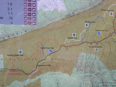
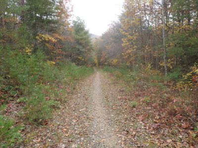
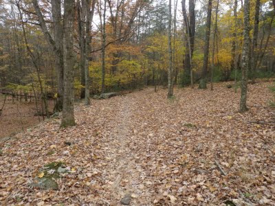
All levels of racers start and end on the southwestern end of the Poverty Creek trail. The 10 mile beginner race starts by riding northwest on a clockwise loop on the following trails in the following order: Poverty Creek, Trillium, Skull Cap, Queen Anne, and Poverty Creek. The trail starts in a field and hops onto a gravel road before connecting to Poverty Creek trail. Racers will make a left turn onto Poverty Creek where the trail sign can be seen in the following picture.

The Poverty Creek trail begins with a long steady climb and then rolls up and down on moderately smooth single track. It is a great trail to start a race because it gets your heart pumping while providing some time to zone in before it becomes more difficult.

On the ride out, it has two steep but short climbs.

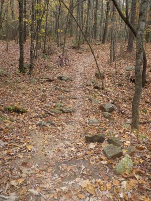
All racers ride on Trillium for ~1.0 mile before turning left on Skull Cap trail. Trillium is rockier and more technical than Poverty Creek and includes one prolonged climb and one mildly tricky descent. In 2009, the leaves and wet conditions made some stretches of trail slippery but the race is a month earlier this year so leaves should be less of an issue.
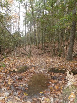
It also includes a few areas where puddles can form if it happens to rain before the race.
Turn left onto to the Skull Cap trail, which is also 1.0 mile long but includes a combination of both tree roots and rocks. It is the most technical section of trail that the beginner racers will ride on. There is one noteworthy, tough climb.
The following picture is backwards looking and shows a two foot drop that I will be walking my fully rigid bike around ;). A similar two foot drop on Young Gulch Trail in Colorado broke my rear axle so I have been avoiding them ever since. In 2009, a video camera was setup about 5 yards down the trail that likely captured some sweet jumps from riders better than me.

Sport/Expert and XXC racers will turn left onto Prickly Pear trail (not documented here) while beginner racers will turn right when Skull Cap dead ends at Queen Anne trail. The Sport/Expert racers ride Prickly Pear, Royal, left on Poverty Creek, right onto Joe Pye, to Horse Nettle, to Snake Root, to May Apple, and Poverty Creek back to the finish line. XXC racers ride two laps of the Sport/Expert course. I have documented most of these trails in greater detail on the Poverty Creek Trail System page. My guess is that the most challenging part of the Sport/Expert/XXC race is the 600 foot climb on Horse Nettle.
The Queen Anne Trail is 0.5 miles of fast, smooth, and descending trail that ends at State Route 708. This short stretch of trail is the fastest and easiest that the beginner racers will ride.

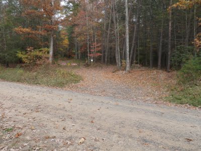
Beginner course racers will turn right onto State Route 708 before quickly bearing left onto Poverty Creek trail. The following picture shows the Queen Anne trail ending at State Route 708. The final 100 foot approach to State Route 708 contains a set of gnarly tree roots hiding under leaves and that caught me off-guard.

Beginner racers double back on Poverty Creek for about 4.5 miles of mountain biking that consists of stream crossings and puddles. The first section of Poverty Creek trail is fast and flat as it follows State Route 708. Further, it provides an opportunity to recharge before tackling the final set of climbs on the other side of the road.
Poverty Creek trail crosses Poverty Creek several times but as of September 16th all of the stream crossings were dried up.

All racers will follow Poverty Creek trail back to the finish line including the State Route 708 crossing seen in the subsequent picture.
Riding on Poverty Creek trail in the reverse direction provides much of the same challenges as the beginning of the race which include fast descents, quick climbs, and a few technical switchbacks.

In sum, the 2009 and 2010 Rowdy Dawg mountain bike races were a lot of fun. It should be noted that the beginner course is more demanding than its name implies.

thanks for the images. Blacksburg and Virginia in general are really beautiful. I lived in Blacksburg when I was a little girl. Its was a great place to be a kid.
Thanks for the comment. We recently moved to Blacksburg and love it so far. Our 2 1/2 year old daughter likes it too. I have a question for you. Please e-mail me at twoknobbytires@gmail.com , thanks.