Hewlett Gulch trail is located 22 miles northwest of Fort Collins, Colorado in the Poudre River Canyon. Specifically, it is 10.5 miles west of the CO-14 and US-287 intersection and on the right side of CO-14 with the trail head on the other side of a bridge. Primary outdoor activities include mountain biking and hiking with dogs. The limited change in elevation is conducive to hiking with kids but the many stream crossings should be considered. Parking is free and includes enough space for a horse trailer but space can be limited on a busy day. The parking lot includes restrooms but no water and limited cell phone service. Other hiking trails in the Poudre River Canyon include Gateway Natural Area, Greyrock Mountain Trail, and Young Gulch. Mountain biking in Young Gulch is similar but more difficult than in Hewlett Gulch.
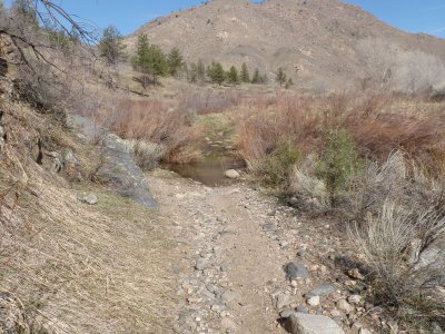
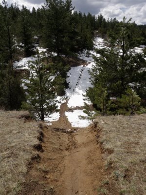
Hewlett Gulch trail is maintained by the Arapaho & Roosevelt National Forests. It is 3.0 miles one way with a mild elevation gain from 5,600 feet to 6,200 feet. The main trail follows Gordon Creek until it reaches private property. However, there is an additional loop that can be explored. The following picture shows the beginning of the trail.
 The trail crosses Gordon Creek numerous times so mountain bikers should be prepared to get wet and hikers to carefully navigate some of the wider crossings.
 Although numerous, the stream crossings are narrow and shallow (i.e., less than a foot deep) which is advantageous for both mountain bikers and dogs.
 Some of the stream crossings are rocky enough to provide technical challenges for bikers but should pose few problems to hikers.
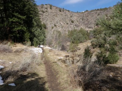
 The following picture illustrates an intersection where the main trail stays to the right and the additional loop bears left. The additional loop reconnects to the main trail at the end. Hikers can have an enjoyable experience traversing the loop in either direction. However, turning left at this intersection means that mountain bikers will experience a long, steep, and rugged climb. Thus, I recommend mountain bikers continue on the main trail and connect to the loop at the end.
 This trail consists of an interesting dichotomy between rocky stream crossings and smooth, narrow single track.
 What’s more, there were several sections where the brush had grown across the trail and was providing resistance that made it tough to bike through. The trail head warns that in the late spring and summer, wood ticks can be found near brushy areas so bug repellent is recommended.
 Traveling farther on the trail offers more scenic views and a healthy mix of sun and shade. Colorado Black Bears can be found foraging near the trail during their fall feeding frenzy. In addition, mountain lions can be present but are rarely seen.
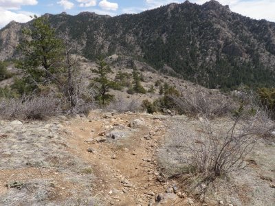
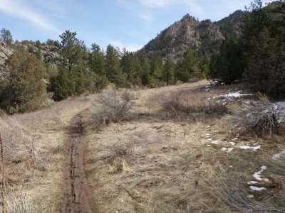 The following picture shows the start of a long climb and represents the end of the main trail. Up to this point, the elevation gain has been unnoticeable. Turning around here makes for an easy mountain bike ride back to the parking lot. However, continuing on the additional loop results in a commitment to bike on a steeper and significantly more rugged terrain.

The additional unnamed loop is a continuation of the main trail, 2.6 miles long, and climbs 600 feet to 6,800 feet in elevation. The additional loop rides west and then descends south. Specifically, it connects to the main trail 2.0 miles from the parking lot and, thus, the ride totals 7.6 miles.
 The set of initial climbs and descents on the loop are long, challenging climbs on smooth, single track.
 The following panoramic picture highlights the view experienced from climbing up the initial hill.
 The trail continues to climb and its smooth single track reminds me of the Blue Sky Mountain Bike Trail in Horsetooth Mountain Park.


Looks like a great hike or bike ride. I sure hope that today’s fire will not destroy what appears to be a great place to explore. Thank you for the information you provided on this website. I hope to visit this trail this summer, provided the fire doesn’t close the place down and or destroy what looks to be a great place. Thank you again!
Mike from Castle Rock, CO
Mike, you’re welcome! It sounds like the fire is close to these trails but like you said, hopefully the damage will be limited.