
Pearson-Arastradero Preserve is located west of I-280 and off of Alpine Road. Hiking, mountain biking, dog walking, and horseback riding were popular on these trails. On my first visit, I started from Sand Hill Road, biked on the road, and did not see parking or restrooms. My cell phone service was strong while in the park.
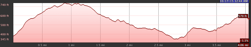
I entered the park via gate C and John Marthen’s Lane. It was too steep to ride up on my Niner single speed and, thus, I walked the latter half of the road. I biked a four mile loop that started and ended at gate C and which included a range in elevation of 300 feet.
I biked a counter-clockwise loop on Meadowlark trail, which started with a moderate uphill climb.
 From there, the terrain rolled up and down with various slope grades. Most of the trails were wide, fast, and smooth gravel.
 I hopped off Meadowlark and checked out the view at the end of Vista Point Trail, which included the Stanford Dish.
 I continued on Meadowlark to its intersection with the Portola Pastures trail.
 From there, I turned right and took the de Anza trail to gate B and then onto the Woodland Star trail.
 I completed the Meadowlark loop on the Woodland Star trail. It was a fun single track but short in length.
 In sum, I found these trails to be easy and a good fit for my single speed. I have a lot more exploring to do here.
