Roxborough State Park is 30 miles south of downtown Denver, Colorado and 13 miles southwest of the intersection of CO-470 and US-85. Primary activities in the park include hiking, birding, snowshoeing, and cross country skiing. Horseback riding, mountain biking, hiking with dogs, backcountry camping, rock climbing, and motorized vehicles are not allowed because the park is designed to minimize impact on natural resources. A Colorado State Parks annual pass or the purchase of a day pass (~$6) is required. Restrooms are available at two of the three parking lots and water is available at the visitor center. All three parking lots are within walking distance of each other. Cell phone service was available along some of the ridges but not in the valleys.

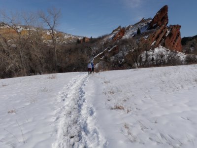
Willow Creek trail is a 1.4 mile loop that hovers at around 6,200 feet in elevation. It is an easy, family friendly trail that cuts through a riparian habitat (i.e., Willow Creek) and that is home to foraging mule deer. We hiked in snowshoes around the Willow Creek loop counter clockwise for 0.45 miles; at which point we transferred onto the South Rim loop.

The South Rim Trail is a 2.0 mile loop that rises from 6,200 to 6,500 in elevation and back down to 6,200 feet. It features spectacular views of uplifted and eroded sedimentary rock that represent Colorado’s rich geological history. Geological formations that can be seen include the red sandstone Fountain Formation (300 million years old), Lyons Sandstone Formation (280 million years old), Dakota Sandstone Formation (a.k.a. Dakota Hogback and 100 million years old). The cream-colored and brick red Lykins Formation (250 millions old) can be seen here but is rarely exposed for viewing since it is so soft. Check out the book Ancient Denvers for a descriptive illustration of Denver’s geological history.
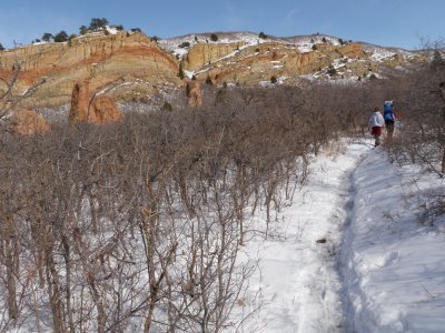
The southwestern half of South Rim trail includes a dense collection of scrub oak stands that provide cover for numerous mule deer that lurk nearby. However, the scrub oak stands do not provide much cover for hikers so the sun is unabated.
 The following video was taken about half way up the southern ridge and includes a view of the valley in the center of park.
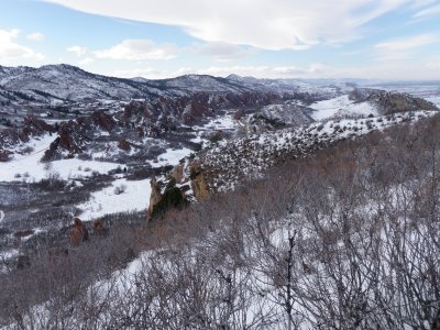
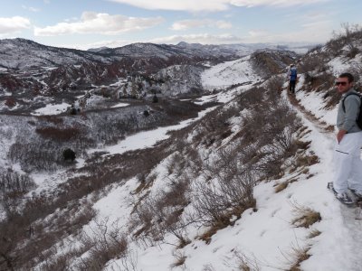
The next picture shows a view from the southern end of the trail and illuminates the awe-inspiring view to the north that showcases the entire park. Hiking from the valley to the top of the ridge involves a moderate elevation climb that is made easier by several switchbacks.
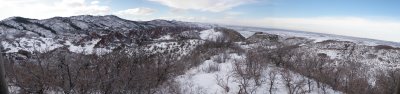
 The subsequent panoramic picture was taken from a lookout point on the southeastern side of the South Rim trail. On a sunny day, downtown Denver can be seen from here.
 The eastern half of this trail sits on top of an exposed ridge so views to the west are unobstructed for the remainder of the hike. In addition, Mountain Mahogany is found on this half of the trail.
We completed the ~3.0 mile Willow Creek-South Rim trail loop with a 0.25 mile stretch of Willow Creek trail that brought us back to the parking lot.
 In sum, Roxborough State Park is a picturesque place bursting with interesting geology and wildlife. Specifically, the South Rim trail is an easy trail with a moderate gain in elevation that should be fun for hikers of all skill levels.
