Carvins Cove Natural Reserve is located north of Salem, Virginia and less than eight miles from downtown Roanoke. Primary activities include hiking, hiking with dogs, mountain biking, and horseback riding. The parking lot with the best trail access is the Bennett Springs Trailhead and Parking Area. It is a huge parking lot and can be reached by taking I-81 exit 141 to VA-419N toward Salem, turning onto VA-311N, turning right at VA-740/Carvins Cove Rd, and following it until you reach a large parking lot on your right. Parking requires a day or annual pass that can be purchased at Just the Right Gear bicycle shop on VA-311 or at the Boat Dock office on the east side of the reservoir. The trailhead does not include restrooms or water. Cell phone service is relatively strong on most of the trails. The following Google Map shows GPS coordinates for trails I have explored on my mountain bike.

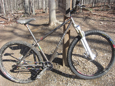
Carvins Cove offers an incredible set of single track trails that range from fast and easy to rugged and vertical. The following are trails I have explored on my fully rigid 2003 Giant Boulder and Niner SIR 9. The trails are listed in order of easiest to most difficult. Each trail title includes the number used on the free Carvins Cove map.
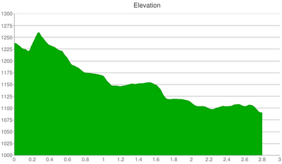
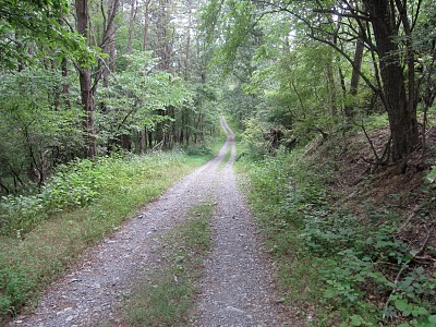
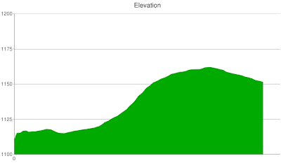
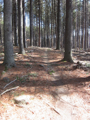
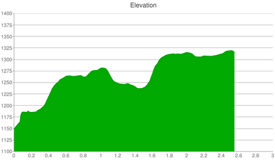
Happy Valley trail is an old gravel road that serves as one of the two main arteries in the Carvins Cove trail system. The GPS coordinates, elevation chart, pictures, and descriptions are from a ride that started at the intersection with the Arrowhead trail and finished at the gate where the trail ends at VA-740/Carvins Cove Rd. From Arrowhead, the trail is about 2.4 miles long with a drop in elevation of 130 feet.
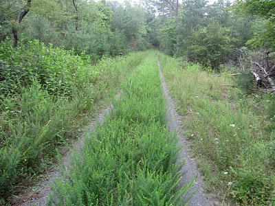
The plants are overgrown in some areas and, not surprisingly, I picked up a tick along the way.
Ride around Riley’s Loop (Trail #22 on the trail map) to get a glimpse of the northwest corner of Carvins Cove Reservoir. I didn’t see any trail markers for this loop but it is hard to miss.
Happy Valley makes it easy to exit the park quickly which can be useful when a storm is approaching.
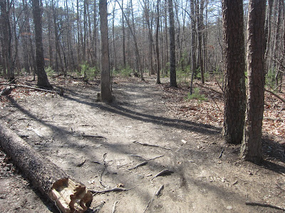
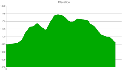
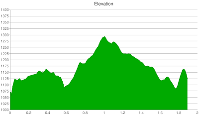
Brushy Mountain trail is the other main artery that connects numerous trails. I have ridden a small portion of it; starting at Buck and finishing at Hi-Dee-Hoe. The aforementioned segment is about 2.8 miles long with a 400 foot elevation gain. The following chart’s right side is exaggerated because I don’t remember a steep climb.

The trail is a wide, dirt road. It is a long but gradual ascent from Buck to Hi-Dee-Hoe. I rode a loop in the following order: Hotel, Buck, Brushy Mountain, and Hi-Dee-Hoe. A loop in the reverse direction should be a significantly faster ride because you can fly down Brushy Mountain.

Little Bell is 0.3 miles long with only a 50 foot change in elevation.
It connects Enchanted Forest to Schoolhouse such that you can spend more time on single track and less time on the service road, Happy Valley.
Enchanted Forest is 0.8 miles of rolling single track that ascends and descend across a range of 100 feet.
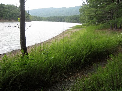
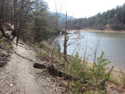
It is a fast, easy trail that curves gently. It comes close to the lake’s shoreline and offers a quick view of it. A short section of this trail overlaps with Happy Valley so it transitions from single track to service road and back to single track.
Songbird is a little over 2 miles long with a change in elevation of 200 feet.
It is a great trail to start on because it is fast, smooth, and curvy. In addition, it has no long climbs and few rocks or roots.

It includes one log bridge that I have not attempted.
After Songbird, I usually ride on Arrowhead trail.
Tuck-A-Way is about 2.2 miles long with elevation change less than 100 feet. I road on Tuck-A-Way as the last part of a loop that consisted of Comet and Jacob’s Drop. From Jacob’s Drop, it starts with a challenging down and up dip. After the dip, it is fast, straight, downhill, and free of obstacles (if my memory is correct). It finishes with a fun stream crossing.

From the Comet trail, Jacob’s Drop is a short, fast downhill ride on smooth trail. It was not clear to me where Comet ended and Jacob’s Drop started so the GPS coordinates and elevation chart are rough estimates. There is one especially fun descent at the beginning and then a less precipitous descent (seen below).

Schoolhouse is about 2 miles long with an elevation change of 350 feet. It is a fast, easy trail that can be accessed by riding on two other easy trails: Enchanted Forest first and then Little Bell.
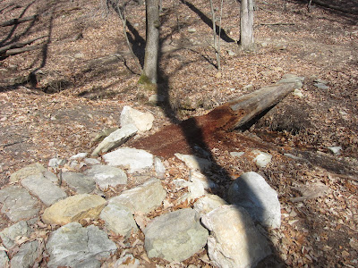
It starts and ends at two different intersections with the Happy Valley trail. Depending on the amount of recent rainfall, it has two to three stream crossings. The following was the largest.

This trail is unique in that it includes a picnic table near the lake.
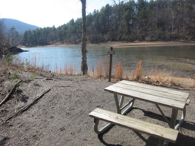
I enjoyed the lake scenery and had no problem riding this trail on my single speed Niner SIR 9.
Four Gorge is about 2.5 mile ride from the trailhead to the Brushy Mountain trail intersection. It has an elevation gain of around 200 feet.
The trail is fast, rolling, and free of obstacles that may require dismounting (e.g., fallen trees, large rocks, crazy technical corners).

So far, this has been my favorite mountain bike trail in the state of Virginia because it is fast, includes some short climbs, and has moderately technical rounded corners; all of which fit well with my bike and current skills.

Arrowhead trail is about 2.5 miles long with an elevation climb of a 100 feet. Combine it with Songbird and Happy Valley to form a quick and fun loop.

The trail begins with an easy climb and feels similar to Songbird.

After the easy climb, it becomes more rugged and more technical. For example, see the following dip that includes both rocks and tree roots.

Arrowhead’s 100 foot elevation gain feels more difficult that it sounds because its rugged sections have obstacles (see tree roots below) that require additional power and stamina to conquer.

Hotel is about 0.8 miles long with an abrupt elevation gain of 100 feet.

It is very rugged with lots of tree roots and fallen trees. One of the first obstacles is a handmade ramp; which I did not attempt since I couldn’t see what was on the other side. It appears to be safe but does include a couple of protruding nails that can pop a tire.

Although Hotel is short, it is action-packed with dips, tight turns, and drops.

It finishes with an aggressive climb that is made more difficult by a myriad of tree roots. Safe to say, I had to walk up the last leg of this climb due to fatigue and the tree roots giving me problems.

After Hotel, I rode on Buck to Brushy Mountain to Hi-Dee-Hoe to the parking lot.


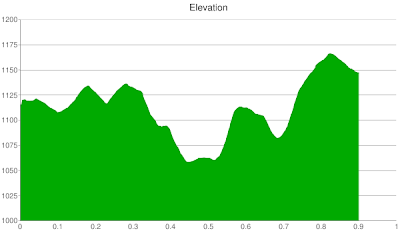
I rode downhill on Hi-Dee-Hoe starting at its intersection with Brushy Mountain trail. Notably, the Gauntlet trail intersection is much closer to the Hi-Dee-Hoe intersection than the free trail map portrays. My phone lost GPS signal mid-ride so the following elevation chart has an exaggerated drop towards the end. It estimates the trail as being 1.8 miles long with a 600 foot drop in elevation.

From Brushy Mountain, Hi-Dee-Hoe starts with several very tight switchbacks; none of which I attempted.

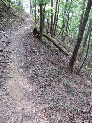
In the between the switchbacks, the trail is narrow and positioned along the side of a steep slope. I don’t recommend this trail for people with a fear of heights or anyone with bad luck because a fall towards the ravine would be a long one. The subsequent picture shows another challenging switchback.

After navigating several switchbacks, the trail transitions into a rapid, easy descent.

Buck is the most difficult trail I have been on in the Carvins Cove trail system. It is about 1.5 miles long with a 300 to 400 foot elevation gain.

My ride on Buck started at its intersection with the Hotel trail and, from there, I headed toward the Brushy Mountain trail. The first half of the trail mirrors Four Gorge with its rolling terrain and moderate challenges.

About half way, the trail has a confusing junction where ultimately you stay to the right and begin a set of precipitous, grueling climbs.

The climbs are unrelenting and especially grueling because they are overlaid with rocks, tree roots, and tight corners. The following is a backward look at one of the switchbacks.

I didn’t get pictures of it but some sections of trail seemed impossibly technical and rugged. Needless to say, I spent a fair amount of time walking my bike up this trail because I didn’t have the stamina or the skill necessary to ride it clean. The next picture illustrates one of the last climbs and the narrowness of the trail as its get close to intersecting with the Brushy Mountain trail. I took a left at the intersection with Brushy Mountain trail and rode it until I got to Hi-Dee-Hoe.
In sum, Carvins Cove has an amazing set of mountain bike trails that range from beginner to adrenaline junkie. Hopefully this blog post will help you plan a ride that suits your riding level. Other mountain biking trail systems in the region include:

Fantastic article! Thanks!
Thanks for the informative articles on Carvin’s Cove & the other mtb trails around the Roanoke area. Been cycling over a year on a hybrid bike, mainly greenways and rail to trails. Bought a mountain bike last week and really looking forward to trying it on some of these trails.I now have some insight on what to expect.
You’re welcome and I hope you have fun on the trails.