Ramsay-Shockey Open Space is part of the Larimer County Parks and Open Land Areas and is located 30 minutes southwest of Loveland, Colorado via US-34. Parking passes are required at all of the parking lots. Be sure to purchase a parking permit at the Bison Visitor Center before arriving at Ramsay-Shockey. The Bison Visitor Center is 4.3 miles east of Ramsay-Shockey Open Space and located on Highway 31 just off of Pole Hill Road. Primary activities are hiking, fishing, mountain biking, horseback riding, walking leashed dogs, and birding. The north and south parking lots have restrooms and free pet waste bags, but no water. Cell phone service was not available for us while in the park.

The Shoshone trail is 2.0 mile loop that includes seven interpretive stations and a mild elevation gain of 300 feet, from 6,600 to 6,900 feet. The parking lot has interpretive trail guides you can take with you on your hike. The interpretive guide explains the significance of each interpretive station along the trail. The first interpretive station is located at the beginning of the trail and describes how Pinewood Reservoir is part of the Colorado-Big Thompson Project which brings water from the western slopes of the Rocky Mountains to the Front Range. On the day we visited, Pinewood Reservoir was a busy hub of fishermen fishing for trout and tiger muskie.
The second station is reached by hiking counter-clockwise on the Shoshone trail loop. It talks about how planned fires can help thin out forests so that they do not become unnaturally dense.

The third station highlights a corridor that is frequented by wildlife such as elk, mule deer, black bears, raccoons, coyotes, red fox, Abert’s squirrels, lizards, porcupines, and striped skunks. The hike from station 2 to station 3 is where most of the 300 feet elevation climb is experienced.

Station 4 reminds you to stop and smell the flowers, shrubs, and trees. Flowers found here include prairie coneflower, gayfeather, bluebells, larkspur, and yucca. Shrubs and trees include mountain mahogany, rocky mountain ponderosa pines, rocky mountain junipers, and douglas firs.

Station 5 encourages open space stewardship by highlighting some of the leave no trace principles. From station 5 to station 6, the trail loses 300 feet in elevation and, thus, returns you back to the elevation from which you started.

Station 6 (not pictured) states that the trails are named for ancient peoples (e.g., The Shoshone Indians) and is the intersection of the Shoshone and Besant Point trails. The Besant Point trail is 2.0 miles long with no elevation gain. The Besant Point trail is a very peaceful walk that follows the shoreline of the Pinewood Reservoir while cutting through an open landscape.

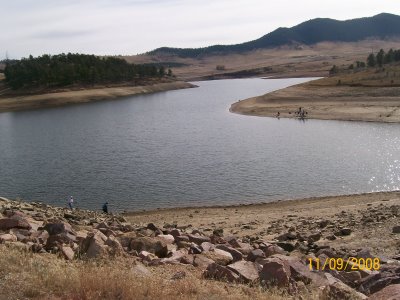
Station 7 (not pictured) documents the birds that inhabit or migrate to Pinewood Reservoir. Birds that can be seen include mallard duck, wild turkey, western grebe, red-tailed hawk, northern flicker, mountain bluebird, Steller’s Jay, great blue heron, and common merganser. The following picture taken from the Besant Point trail shows the northern view from the southern edge of the reservoir.
 In sum, these trails provide easy to moderate hikes suitable for the whole family and that can be combined with fishing and birding. Other great hiking trails nearby include Devil’s Backbone and Crosier Mountain.

Very nice. I think sometimes we forget how lucky we are to be in places where we can enjoy the great outdoors. Keep up the good work.
Time Outdoors, thanks! It look like you have three great blogs started.