Mount Sanitas is located less than 10 minutes from downtown Boulder, Colorado. Primary activities include hiking, trail running, and hiking with dogs. Parking at the trail is free but limited in space. Since the trailhead is only five minutes from downtown Boulder, many people walk or ride their bikes to it. Restrooms and water are not available but cell phone service was available in most of the park.
Mount Sanitas Trail
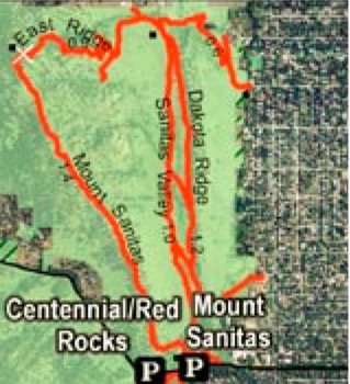
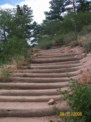
We hiked the Mount Sanitas trail as a loop using the East Ridge and Sanitas Valley trails. It is a vertically challenging 3.3 mile trek. Reaching the summit requires climbing 2,200 feet, starting from 5,600 and rising steadily to 6,800 feet. As you can see in the subsequent picture, the vertical characteristics of the trail can be likened to a natural stair stepper machine.
The summit provides a mid-level view of Boulder, CO. Considering the popularity of this trail, the summit has limited space for hikers looking to eat a peaceful, relaxing lunch.

The Mount Sanitas summit provides about a 240 degree view of Boulder to the east and of the front range to the north and south.
The East Ridge trail connects to the Sanitas Valley trail and, thus, forms a loop. It is curvier than the Mount Sanitas trail but still as vertically challenging. The main attraction of doing a loop around Mount Sanitas is to finish with an easy level walk on the Sanitas Valley trail. However, descending the East Ridge trail appears just as difficult as descending the Mount Sanitas trail so choosing the East Ridge + Sanitas Valley trail combo does not reduce the descent difficulty or length.
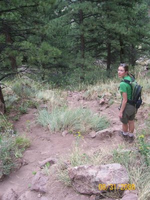
 We believe the following picture shows where we made a wrong turn. Instead of heading southeast, we should have continued east. As as result of our wrong turn, the trail forced us to do some reverse bouldering to lower ourselves down with a Kelty child carrier on our back. The interesting thing (or frustrating thing) about Mount Sanitas is the trailhead contains a brochure detailing the importance of hikers staying on the trail to protect wildlife habitats. Yet, at an important trail juncture, there were no signs to guide us and the trailhead did not provide a trail map to take with us. However, it should be noted that many people were later seen having correctly completed the East Ridge trail so we will blame our mistake on our urgency to return to the trailhead before an afternoon storm came upon us.
Sanitas Valley Trail
The Sanitas Valley trail completes the loop. It is a level, wide trail suitable for running, jogging strollers, leashed dogs, hikers, and nordic walkers. Mountain bike trails branch off of it on both sides.
 In sum, this hike is vertically challenging both on the way up and coming down along the East Ridge trail because there are very few level spots. As a result of the trail’s close proximity to downtown Boulder, many of the people on it appeared to be doing a routine jaunt. The Boulder Open Space and Mountain Parks contains over 131 miles of hiking trails and 43 miles of mountain biking trails. In addition to hiking Mount Sanitas, we recommend hiking on the Chautauqua Park Flatiron Trails.

We are among the lucky ducks who live within easy walking distance of the Sanitas trailhead. Some years, my husband and I have kicked our willpower into gear and taken an almost-daily early-morning walk up Sanitas Valley and back. Before the dogs arrive, we have seen deer and a couple of times even a coyote. On one occasion in spring, a coyote was after what we assumed was a fawn sheltered in some bushes. Three does cooperated in driving off the coyote. A wonderful wildlife experience just blocks from our home.When we do the entire Mt. Sanitas/Sanitas Valley loop, we tend to hike it clockwise, first climbing the steps that you photographed, then threading through the rocks at the summit, switchbacking down the east face of the mountain and finally descending on the wide, smooth Sanitas Valley Trail. Thanks too for mentioning Nordic Walking in your list of permitted uses.Claire @ http://nordic-walking-usa.blogspot.com
Claire, have you ever made a wrong turn like we did on the East Ridge Trail?